Howell
Howell Graveyard, Risler Street, Borough of Stockton

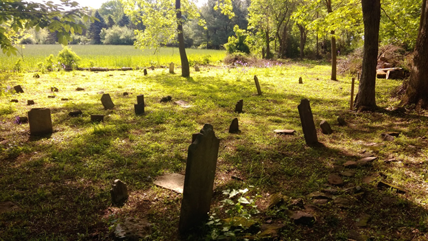
The Howell Graveyard is located on 1440 acres of land acquired by West New Jersey Proprietor Col. John Reading in 1709. About 1710 his daughter Mary married Captain Daniel Howell and he gifted about one square mile of land west of the Wickecheok Creek which includes present day Stockton to the couple. Daniel Howell died in 1733 and Mary probably in 1732. In his will Daniel leaves the land to his six children as “Item, I give and bequeath unto my said sons Daniel and John the Cornor [sic] Grist Mill … together also with 60 acres of land… Item, I give and bequeath unto my said sons Joseph and Benjamin the remaining part of the Plantation…divided between them share and share alike according to the Quality thereof.”
After more than two years legal action the Borough of Stockton, NJ at lasts owns the previously abandoned Howell graveyard, a.k.a. the Rittenhouse/Prall cemetery. The order vesting title to the Borough of Stockton was recorded on February 22, 2018 at the County Clerk’s office in Flemington. The order was issued by the Superior Court on January 16th on the approval of the petition to claim ownership filed on December 28, 2017.
In June 2018, The Mount Amwell Project, Inc. and the Borough of Stockton executed a lease giving us the responsibility to clear and maintain the graveyard for the next 50 years.
Access to the graveyard is over the service road through the adjacent land owned by the New Jersey Conservation Foundation. Fortunately, we executed a Memorandum of Understanding (MOU) with the NJCF in 2015 that allows us use of the road which is normally off limits to the general public.
On September 22nd, October 6th and Oct 20th volunteers cleared approximately 35% of brush and fallen trees of the one half acre Howell/Rittenhouse graveyard. Over 100 head and foot stones were counted with one discovered about 200 feet from the north side of the 300 year old graveyard. Volunteers include Stockton Borough Council members Paul Bergquist and Don Vandergrift, MTAP members Ray Simonds, Bob Leith, and Dave Voorhees, and Mark Wells, facilities manager at the Prallsville Mill complex. The work was performed compliant with The Mount Amwell Project lease signed with Stockton Borough in June which assigned responsibility to the MTAP to preserve and protect this important historical graveyard.
During the 3rd day of clearing the mound pictured above was revealed and tentatively identified as a possible Indian Burial mound by Bob Leith and Dave Voorhees. It was similar to the mounds recently discovered by Gregory C. Herman, Ph.D. on Cushetunk Mountain in Readington Township. He presented the results of his first phase of research into the nature of the ancient stone cairns upon Cushetunk Mountain in Flemington, NJ at an event sponsored by the Hunterdon County Historical Society and the Hunterdon 300th initiative on September 15, 2018.
Dr. Herman has written, that “Historical research shows that the Cushetunk stone mounds may represent a cultural overlap between Late Archaic or Early Woodland mound builders and the Lenape. There is good evidence the Cushetunk mounds shave a common ancestry with stone mound builders occupying the Susquehanna Valley of Pennsylvania and adjacent parts of western NY. Probable sepulchre mounds on Cushetunk Mountain are reported to contain a lineage of warrior chiefs spanning at least seven generations and contain artifacts unlike the Lenape at the time of colonial contact.”
At this time is has not been determined the date or history of the Howell mound, but there is some evidence that the hill above the Delaware River near Stockton was a Lenape burying place. There are several places on the hill containing what appears to be remains of stone mounds. The fact that they are placed in a scattered fashion is consistent with Lenape burying practices described by Herbert C. Kraft in his book The Lenape-Delaware Indian Heritage where he describes on page 344 the practice as “The placement of graves was more or less haphazard; sometimes the remains were located close together, but most often they were located here and there across the site.”
